Many teams already operate DJI drones such as the M3, M4, M300, M350 and M400. Yet bridge inspection presents a different challenge: not whether the aircraft can fly, but how its inspection route should be planned.
A bridge contains piers, pier caps, cross beams, bearings, hollow slabs, box girders, T-girders and parapets, as well as towers, stay cables and suspension cables. Each component has a different shape and size and requires a suitable shooting distance and angle.
Manual flying may work for a bridge tower, but inspecting dozens of stay cables at close range makes consistent distance and coverage much more difficult.
Arch, cable-stayed and suspension bridges add curved surfaces and irregular components. Without advance planning, ad hoc image capture can result in missed areas, duplicate images or blur, leading to costly repeat work.
The first challenge in bridge inspection is therefore not simply having a drone, but having a route suited to the structure.
AIFORAIL developed ARP bridge route planning software to address this need.
01 Why does bridge inspection need more than ordinary route planning?
Area-based grid routes commonly used for mapping and aerial photography do not directly meet component-level inspection needs. The aim is not merely to photograph the whole bridge, but to capture each component clearly.
The differences involve three main issues:
First, component awareness. Conventional routes are drawn around geographic areas, whereas inspection is organized around individual members. What angle is needed for a pier? Should the drone follow a stay cable closely? Area-based planning does not inherently identify these components.
Second, surface alignment. Bridge members include curves, folds and vertical faces. A flat coverage grid may not match their surfaces, leaving the camera too far away or at an unsuitable angle.
Third, complex geometry. Arch ribs are curved, cable-stayed towers and cables follow inclined lines, and suspension cables and hangers have other orientations. Regular planar routes alone cannot describe all these structures.
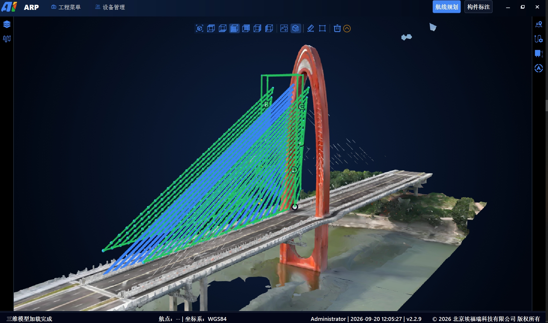
ARP labels components in a 3D bridge model and generates routes around those components rather than around geographic areas.
In short, area-based planning answers where to fly. Bridge inspection also needs to establish which component to follow, from which angle and at what distance.
02 ARP: Understand the components before generating a tailored route
ARP stands for Aiforail Route Planning. Its approach is to give the bridge model a component-based structure, then generate routes around those components.
The software combines the 3D model, component annotation, route calculation and inspection actions in one workspace. Import a model, annotate its members and select the parameters to generate candidate routes that follow the components.
Five steps from a model to an executable route
Step 1: Import the 3D model. Load bridge models in formats such as 3D Tiles and B3DM to establish the spatial reference. The model provides the geometry and dimensions required for route calculation.
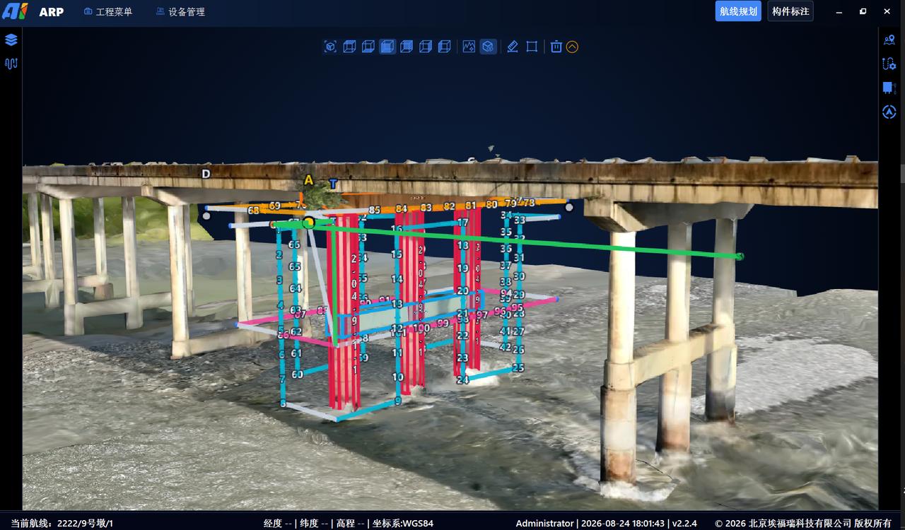
Step 2: Annotate bridge components. Create parameterized objects for piers, cross beams, pier caps, girders, arch ribs and bearings. Colors distinguish the components used in route calculation.
Step 3: Select components and parameters. Choose the members to inspect and configure inspection distance, longitudinal and lateral image overlap, and the task aircraft, including DJI M3, M4, M300, M350 and M400 models.
Step 4: Generate and review routes. The software calculates candidate waypoints, paths, camera directions and actions for preview in the 3D view. Operators review and adjust them as needed.
Step 5: Export task files. Export KML routes for execution. Component and task data can also be exported through project interfaces to connect with downstream image and damage management.
Coverage of a broad range of bridge components
ARP supports the following component groups:
Below the deck: piers, pier caps, cross beams and bearings.
Bridge superstructure: hollow slabs, small box girders, T-girders, large box girders and bridge sides, including parapets.
Above the deck: bridge towers, stay cables and suspension cables.
ARP supports component-based planning for conventional girder bridges as well as arch, cable-stayed and suspension bridges. As geometry becomes more complex, dedicated planning helps address the limitations of manual coverage and image consistency.
03 Review a route before flying with the ARP simulator
Discovering route problems only after a flight can mean missed components, insufficient clearance or images taken too far away. Repeating fieldwork adds time, airspace coordination and labor costs.
ARP includes a flight simulator to support pre-flight review.
After planning, start a simulated flight around the 3D bridge model. Review the starting point, flight path, camera direction at each waypoint and spatial relationship with the structure.
Review the planned flight in the office before taking it to the actual aircraft and inspection site.
Simulation helps reveal route issues before a real flight.
Its practical benefits include:
Earlier problem identification: review component coverage, camera angles and proximity to the structure in the simulated flight.
Less repeat fieldwork: identify planning issues before mobilizing the aircraft and team to the site.
Route familiarization: pilots can review the path and key points in advance, supporting more informed field operations.
Clearer communication: a simulated flight helps project stakeholders and reviewers understand the proposed route.
Planning does not end with drawing a route. It includes checking whether the route supports the intended image capture. Simulation brings part of this review into the office to help reduce field risks.
04 Add professional planning to an existing DJI drone workflow
Many teams already have DJI drones and their own data-processing platforms, but need a dedicated route planning tool.
ARP can operate as an independent planning tool rather than requiring replacement of the entire inspection system. It supports detailed bridge-side and above-deck inspection planning alongside existing aircraft and processing workflows.
Typical coverage includes:
Bridge sides: girder faces, parapets and collision barriers, with routes parallel to the bridge side for sequential capture.
Above-deck structures: towers, stay cables, suspension cables and main cables, using component-based close-range image capture.
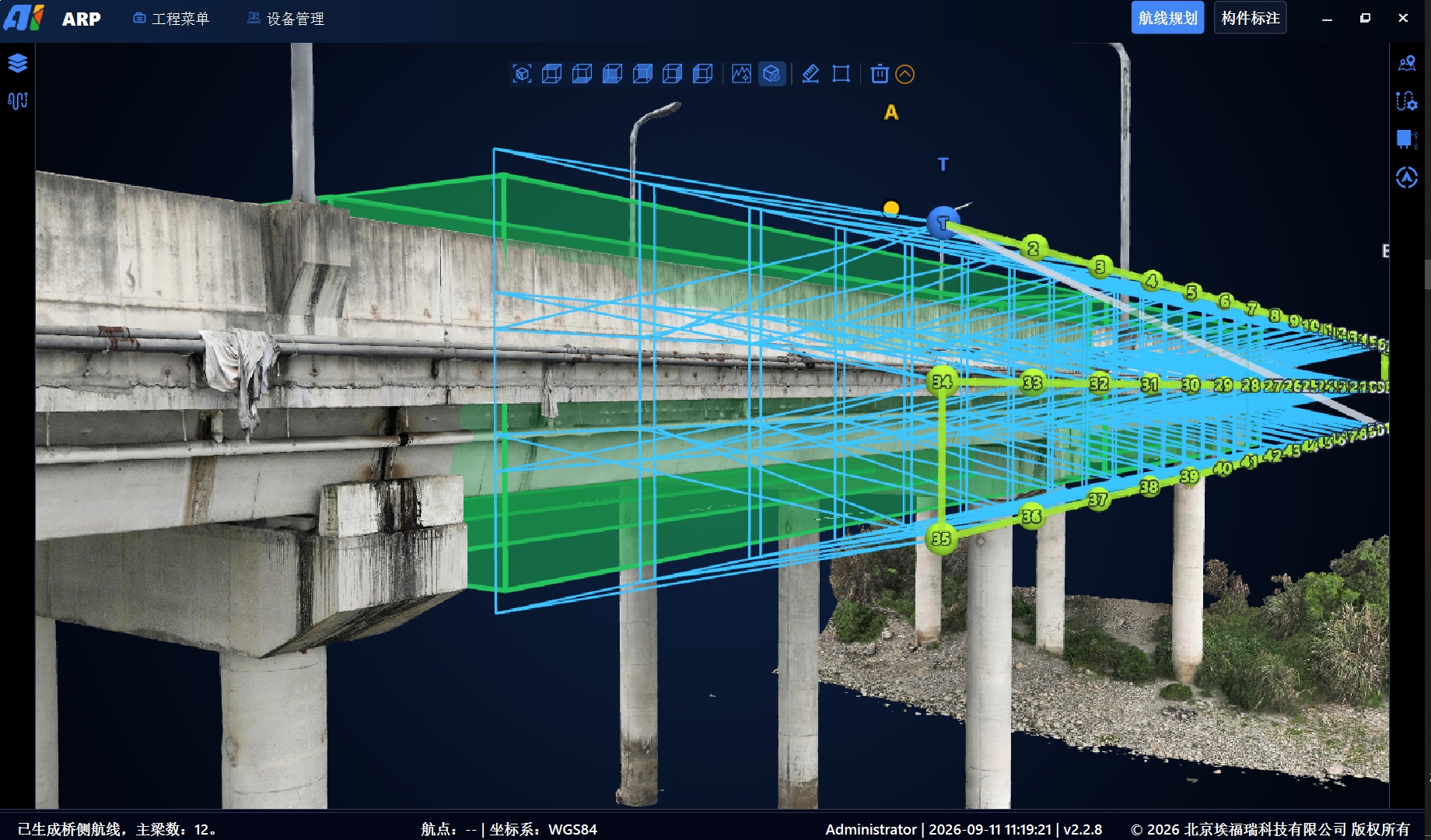
DJI M3, M4, M300, M350 and M400 aircraft can be combined with ARP for bridge-side and above-deck inspection workflows.
The combination is intended to be flexible and to complement existing processes:
Retain existing DJI aircraft rather than replacing the drone fleet.
Retain the processing platform: KML routes and component data can connect to the existing workflow.
Add the planning capability without necessarily purchasing a complete inspection system.
To extend work below the deck, including piers, bearings and girder undersides, INES onboard navigation can address GNSS-denied positioning while ARP continues to plan routes. This supports a staged expansion of capabilities.
05 Project-based rental as an alternative to purchasing
For teams with occasional projects, purchasing software that is rarely used can be difficult to justify.
ARP offers a rental option in addition to conventional purchase.
Software can be rented for a project period to complete planning and inspection tasks, instead of paying the full purchase cost upfront.
This can suit teams in the following situations:
Teams new to bridge inspection can evaluate the workflow before a larger investment. Project-based operators can use the software when assignments require it.
Teams evaluating feasibility can complete a project first, then decide whether a long-term purchase meets their needs.
Rental provides a way to evaluate ARP on a real project before committing to long-term ownership.
Closing thoughts
Flying is only the first step in bridge inspection. Route planning is a key part of achieving useful image coverage and quality.
ARP turns the bridge model into a component-aware task space, generates routes around those components and supports simulation before field execution.
For teams with existing DJI drones and processing platforms, ARP adds the planning step for bridge-side and above-deck inspection. Project-based rental offers another way to get started.
Please contact us to learn more about ARP or discuss rental options.